
2:30pm CST Snow and Tornado Threat Update
The hatched area is where tornadoes are quite likely after 3pm until around 11pm tonight. The black hatched area is a very dangerous region for tornadoes this afternoon.
 Please start monitoring the weather by around 3pm through the red outlined area.
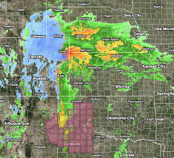 Snow is now falling throughout the Denver-Boulder area this afternoon and it is spreading into southeast Wyoming and the Nebraska Panhandle where blizzard warnings are in effect.
 The orange area in Nebraska is 4+inches. Red is 3+ inches. More rain is forecasted for next week and early the following week. If this is anywhere close to correct, significant flooding will develop in Nebraska, northern Kansas and along the lower Missouri River Valley. If you live or work in these areas, please take heed.

Here is the radar at 2:30pm (update). A second tornado watch has just been issued for the eastern Texas Panhandle and far northwest Texas.

The Front Range area is forecast to have snowfall rates of 3" per hour later this afternoon and this evening. Do not try driving into these areas. If you are planning to fly into Denver, forget it. Check with your airline and get re-routed.
Here is the precipitation amount forecast valid for the next 7 days.

Note: this will be the last routine update on the blog because we've pretty well forecast what is going to occur. You may follow me on Twitter @usweatherexpert for more and I will post again by this evening.


Comments
Post a Comment