
PRELIMINARY: Major Winter Storm Likely Later This Week
There is the potential for a crippling ice and snow storm late this week in the Great Plains
Preliminary Freezing Rain (Glaze Ice) Forecast
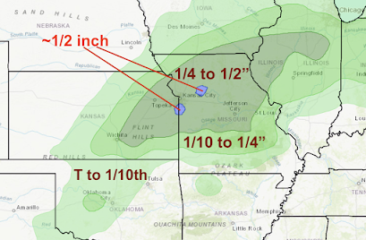
Freezing Rain Accumulations Noon Thursday to Noon Friday.
Of course, amounts may shift up to 50 miles in any direction.
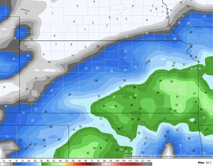
Preliminary Snow Amount Forecast

Snowfall Forecast From 6am Thursday to 9pm Friday
There will likely be drifting snow based on wind speed forecasts for 6am Friday.
Wind Gust Forecast For 6am Friday
Currently, a NWS winter storm watch is in effect from Thursday afternoon into Friday night for the tinted counties. The watch will likely be expanded Wednesday. The watch includes Wichita, Salina and Woodward. 
This is still a preliminary forecast. Storm watches and warnings may have to be extended to the east and northeast with time.
The heavy ice followed by heavy snow has occurred before at this time of year. There was a nearly identical ice storm followed by heavy snow in this region on January 3-4, 1973. Throughout the night of the 4th in Kansas City, eerie blue lighting would appear for a few seconds as power lines fell and shorted under the weight of the ice and snow.

If you are planning to travel late this week, please factor this forecast into your plans.
I will update again during the late morning Wednesday.


Comments
Post a Comment