Posts

Showing posts from November, 2019

Small Business Saturday

Image
Today is "small business Saturday." As a small businessman, I'd appreciate your support. Warnings: The True Story of How Science Tamed the Weather  is a highly reviewed and rated book that tells the uplifting story of the people who created America's unique storm warning system that saves thousands of lives each year. Barnes & Noble From Goodreads: All of the weather advisories and commentary on this blog are provided without outside commercials. So, we'd appreciate your support of our highly rated books. 

Today and Tonight's Weather Risks

Image
The brown area is where there is a signifiant risk of tornadoes. Because of the heavy travel period, I have superimposed the interstate highways. Here is a summary map of warnings across the country. click to enlarge And, the national radar composite as of 1:15pm CST.

NO Upward Trend in Hurricanes Or Tropical Storms

Image
The 2019 North America hurricane season is over. The data is in. And, the data, combined with data from around the world, conclusively shows there is absolutely no upward trend, worldwide, in tropical storms or hurricanes. Dr. Ryan Maue

Travel A Mess in the Western Half of the Nation

Image
If you are traveling today in the western half of the nation, please check local weather forecasts. Here is a map of adverse conditions as of 8:30am today. Things pretty much okay in the East. (Note: this will be the only travel advisory today)

Gasp! World May Have Crossed Global Warming "Tipping Point"

Image
Big Climate's latest focus group must have approvingly coughed up the "tipping point" furball because they are at it again. The item below was published Wednesday. It is the first time I've seen two of their focus-grouped terms (the other, 'climate emergency') in a single eight-world headline. The number of tipped global warming tipping points over the last 40 years is likely well past 100 by now. The first was in 1989 . It proclaimed "whole nations would be underwater" if the problem wasn't solved by 2000. Last time we checked, the Maldives were doing just fine . There have been dozens of tipping points ever since. I wrote this more than five years ago. This headline was published Tuesday. Multiple people on Twitter have speculated the timing of these and other headlines is not coincidental. They were supposed to subtly get you to talk about global warming over Thanksgiving dinner. Me? The only cooling I wanted was for the cranbe

Happy Thanksgiving

Shelley, Mindy and I wish you a very happy Thanksgiving. We have many, many things about which to be thankful in our nation. One of them is all of the meteorologists who are working today -- and are away from their families -- to help keep you and your family safe with the storms crossing the nation. It is well worth reading Sir Winston Churchill's World War II message on Thanksgiving. It is here .

An Innovative Thanksgiving Travel Suggestion

Image
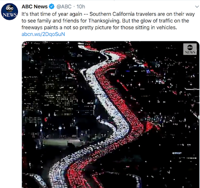
Screen capture from ABC News of California Thanksgiving travelers. It makes me think: Wouldn't it be easier for the people in the red cars (taillights) to visit the relatives of the drivers in white (headlights) and vice versa?? Have a safe drive and a great Thanksgiving.

7am Wednesday Thanksgiving Travel Update

Image
Here is the forecast snowfall until midnight tonight. And, for late travelers, here is the total  snowfall from now through 11:59pm Thanksgiving evening. And, to close our Thanksgiving weather coverage, I'd like to quote Hill Street Blues'  Sgt. Phil Esterhaus: Let's be very careful out there!

Radar at 6:45pm

Image
The blue is the heavy snow from Kansas to northwest Wisconsin. Yellow counties are currently under tornado watches. For additional coverage this evening, please follow me on Twitter @usweatherexpert. 

1:30pm Tuesday Travel Weather Update

Image
Updated at 1:30pm CST. Wildfires already in progress! Scattered power outages likely. Radar at 1:20pm. -- Original Posting --  Hundreds of cars stuck in eastern Colorado. Serious power disruptions and wildfires are likely in the high wind warning areas. Tornado Risk The brown area has a significant tornado risk.  Damaging Thunderstorm Winds The yellow area has a significant risk of wind gusts of 60 mph or more. The red area has an enhanced risk. This is a significant danger for high profile vehicles. Power failures are possible.

Radar at 8:25am CST Tuesday

Image

7pm Pre-Thanksgiving Travel Forecast

Image
Before beginning, please let me remind you that I am focusing on the Central United States as there are plenty of blogs that focus on the East and West Coasts. That said, please keep be aware of high winds forecast for the southern Oregon and northern California coasts along with high winds in the eastern Great Lakes regions. The days to which I refer are from midnight to midnight. If you are flying Tuesday or Wednesday, don't eat a big meal. Turbulence is possible just about anywhere. Current Radar as of 7pm CST Currently In Effect Tuesday Snowfall, again, from midnight to midnight. The heavy snow falling in eastern Colorado and the High Plains will have coated the roads by sunrise. Peak Wind gusts through 11pm Wednesday. click to enlarge Power failures are possible in the deep orange areas and likely  in the red areas. These high winds will also make driving quite hazardous, especially for high-profile vehicles. Also, severe thunderstorms with brief torn

PRE-Thanksgiving Travel Outlook

Image
It is going to be a mess for pre-Thanksgiving travel Tuesday   and  Wednesday. A  second storm likely on Thanksgiving Day itself.  Because there are plenty of blogs that cover the East Coast (especially!) and West Coast, we focus on the central United States. I am going to break things down by 24-hour periods from midnight to midnight. Tuesday Forecast snow: click to enlarge Snapshot of forecast winds for 2pm CST: With snow falling in much of the circled area, wind gusts to 40 mph will cause drifting snow and very hazardous travel conditions. Note: The winds in eastern Nebraska will increase from then until about 10pm. It will be close to blizzard conditions at times. These problems will include I-80 from Scottsbluff to Omaha and I-70 from Limon to WaKeeney. The areas of red on the wind map feature gusts of 55 mph or higher -- very hazardous for high profile vehicles. This will include I-40 from near the Oklahoma-Texas border to Albuquerque. Thunderstorm Forecast:

At Least a Temporary End to the Fire Season

Image
Extremely heavy rains are forecast for California and the Southwest over the next seven days. These rains, with snows in the higher elevations such as along I-40 in Arizona, will disrupt holiday travel. Most of the Colorado and Utah ski areas will have heavy to very heavy snows. ADDITION: Courtesy of NWS San Diego. If this forecast is close to correct, serious flooding will result.

Holiday Book Update

Image
I am happy to report that Amazon has adequate copies (for the moment) in stock for Christmas. The last two cartons of books have been sent to the wholesale warehouse. After those are sold, Warnings: The True Story of How Science Tame the Weather will be out-of-print.  You can purchase a copy from Amazon, B&N or your local bookseller. With regard to the latter, it may take a few days for the final cartons to make it into the system. If they tell you they are out, wait a few days and try again. While there should be adequate supply, I recommend getting your order in as soon as possible. click to read A hardcover book is a cherished gift.

Tenth Anniversary of Climategate

Image
By pure coincidence, Climategate  broke  ten  years ago, this  blog's first  day of publishing.  The newspapers in Great Britain did a far better job covering the biggest scandal in the history of the atmospheric sciences than did their counterparts in the United States. The U.S. MSM did the very best it could do to cover up this story of major scientific misconduct. This blog's first story on Climategate What was most shocking to me were the awful positions taken by the American Meteorological Society and other scientific organizations that, defacto, sided with the wrongdoers. After a few weeks, Climategate, wrongly, faded from the public eye. The MSM, in fact, continued to spout the nonsense from these extremists in the intervening years. I don't have the heart or stomach to recount all of Climategate. If you are new to the story, here are some excellent links: From The Quadrant, here . WattsUpWithThat  (one of the sites that broke th