What An Evening!
National Weather Service's plot of tornadoes so far today:
We were at the oval pointing west for the photo below.
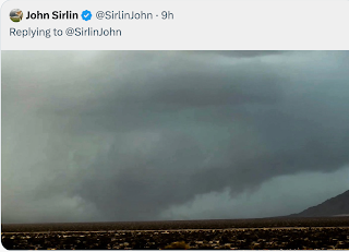
Naturally, the tornadoes we saw were in area with very poor cell coverage, so I was not able to tweet to the extent I wanted. That said, here is the spectacular supercell as it was just southwest of Medicine Lodge:
The rotating, lower part of the thunderstorm's base is called a "wall cloud" by meteorologists. You can see it in the foreground along with a funnel on the north (right) side. But, in the background, you can see -- through the rain -- a large tornado. I've outlined that area with the rectangle.
From the other side, here is what the tornado looked like. I believe these are at the same time, but have not been able to confirm it, so far.
Chris' photo is via Twitter.
I hope to be able to confirm all of this tomorrow -- it has been a long day.


As you said in a post last year -- you guys are getting good at knowing all the conditions that produce the tornado, but haven't figured out yet what makes them "go back up". This could have ended up being on the ground for a long time and doing lots of damage; or like it was this time - only down for a short time and then withdraws. Maybe someday we can figure it out.
ReplyDeleteTracy, I hope we can because it would help with the "false alarm" aspect of warnings. That said, we knew well in advance where the tornadoes were going to be.
ReplyDelete