The Weekend Storm: 7:30am Thursday Update
Here is the latest information on the upcoming storm:
Tornadoes and Severe Thunderstorms
The yellow and red areas are where a significant threat exists during the period from 6am Saturday to 6am Sunday.
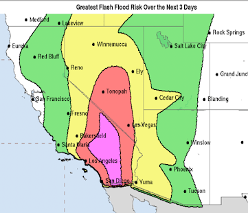
Flooding
The forecast precipitation over the next five days:
Snow and Ice
Here is a map of the forecast freezing rain. Areas where a quarter inch or more are expected could experience power failures. This map is valid for the next 72-hours.
Snow amounts:
Above is the U.S. GFS model forecast. Below is the European model's forecast:
If you average the two, you'll have pretty good idea of the range of possibilities.
I'll be continuing to update the forecast with another complete update this evening.
Tornadoes and Severe Thunderstorms
The yellow and red areas are where a significant threat exists during the period from 6am Saturday to 6am Sunday.
Flooding
The forecast precipitation over the next five days:
Snow and Ice
Here is a map of the forecast freezing rain. Areas where a quarter inch or more are expected could experience power failures. This map is valid for the next 72-hours.
 |
| Freezing Rain Forecast |
Above is the U.S. GFS model forecast. Below is the European model's forecast:
If you average the two, you'll have pretty good idea of the range of possibilities.
I'll be continuing to update the forecast with another complete update this evening.


Comments
Post a Comment