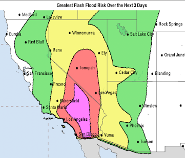
Here is
AccuWeather's latest update regarding the potential ice storm in the southern Plains:
As much as ¾ of an inch of glaze ice is likely from around the Arbuckle Mountains of southern Oklahoma into the southern Ozarks then to the mouth of the Ohio River. Where the heavier ice accumulation occurs, power failures are possible. More about freezing rain
here. How to
prepare for an ice storm here.
Here is the most likely accumulation of snow forecast. In the Rockies and snow is ongoing. In the southern Plains, the storm will commence late Wednesday night and move into the Mississippi Valley during the day Thursday. The heavy snow area in northeast Oklahoma through the Missouri Ozarks will see four to seven inches of snow.


Comments
Post a Comment