
Central U.S. Storm Risk Boosted
Since I posted the forecasts below, several have been updated by the Storm Prediction Center.
Tornado
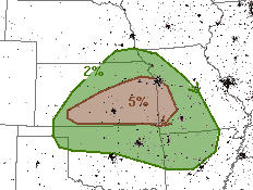 This is the only area with a significant (≥5%) threat. It includes Wichita, Kansas City, Joplin and Topeka.
Damaging Winds
Two areas have been ratcheted up.
 These are very high numbers and the hatching means gusts of 75 mph or above are possible. So, go ahead and bring trampolines and lawn furniture inside and put your car in the garage. Widespread power failures are quite likely if these winds materialize as forecast. Please prepare for power interruptions!
 While not as ominous as the Central U.S. threat, thunderstorms with these winds are more than enough to cause scattered power failures and disrupt air travel though the region.
Hail
 If the winds forecast materialize and drive the hail there will be broken windows, dented cars and damaged roofs. Your car should be in the garage. The significant threshold is 15%. The hatched area is where hail stones larger than 2" are forecast. There is the potential for baseball or even larger hail in some areas.
This scenario is more dangerous than the typical mid-summer severe thunderstorm situation. Please plan accordingly.
Tornado

Damaging Winds
Two areas have been ratcheted up.


Hail

This scenario is more dangerous than the typical mid-summer severe thunderstorm situation. Please plan accordingly.


Comments
Post a Comment