Storm #2 in the Series
Is bringing snow to the northern Plains as of 6pm CST.
Blizzard warnings are out (see posting below). AccuWeather regional radar also shows thunderstorms developing from northeast Louisiana to central Kentucky. This will bring moderate amounts of rain to this same region over the next few days.
This is the NWS's forecast for precipitation amounts through 6pm Thursday.
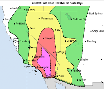
Storm #3 in the series should be over southern California Thursday morning. It will move toward the Plains next weekend.
Next weekend, storm 3 is centered over southern Iowa. Finally, storm #4 (red arrow) is moving southeast toward the West. It will affect the central U.S. the week before Christmas.
So, we have several more opportunities for precipitation in the central U.S.


Comments
Post a Comment