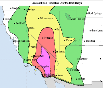
Rainfall So Far + Updated Severe Weather Outlook
Up to 5pm, here is the rainfall from the storm moving into the Rockies.
Here at the Smith House, we have had exactly a half inch. Drizzling outside now. Mid-Continent Airport, on the other side of town, has only had 0.21 inches.
I'm not liking some of the computer model forecasts for tomorrow afternoon. There is little doubt in my mind that tornadoes will occur, the question is where. The Storm Prediction Center, in its early afternoon update, moved the higher risk farther west. I would accept the 30% area as is except that I would probably extend it southwest a bit to Altus and Wichita Falls. If you are in the 30% area, you really need to keep up on the weather tomorrow.
I'm probably going to chase tomorrow if there is something in Kansas or northern Oklahoma worth going after. If you would like to follow along, I tweet @usweatherexpert. I tweet at lot of photography during my chases, so I'd like to have you come along.


Hope some of this comes into the drought area of Wisconsin!
ReplyDeleteSee posting two down.
ReplyDelete