Watching a Tornadic Thunderstorm...
...from a safe location and distance.
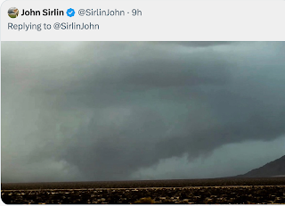
Here is a brief video and you can hear the siren in the background. The lowering in the center was slowly rotating. Saw one very brief well-defined funnel cloud but I never saw a tornado.
the storm continued to move to the east southeast. Here is a funnel cloud moving past my house to the south. The video quality is not great but I could see rotation in it. There had been a report that the circulation had reached the ground at K-96 and Oliver a few minutes below.
I know how to do this safely. Was never in any danger. I moved before the circulation got close.
Watch my blog for storms in southern Kansas. There is no need for you to get out and risk your safety.
Hailing at the Smith House right now. Hail is marble size.
And, here is what the radar looked like when the first video was taken. There was a hook echo, perhaps too large a hook which caused rain-cooled air to undercut the circulation. I'm looking west from the blue "bullseye" symbol:
The Doppler wind display showed imbalanced circulation.


"Hail is marble size." - Ah! Such a pet peeve of mine!
ReplyDeleteNWS Skywarn training advises spotters to never, ever report hail with sizes of items that aren't the same size! Coins work best if there's no ruler around.
Still, you had a great and safe location. With the amount of media(/chaser) coverage available online these days, there really is no need for unprepared people to risk their lives chasing storms. However, as we've see in the past (and will in the future) is that many times the videos we see from an unsafe distance are those that get caught in the tornado's path and don't get out of the way.