Final Live-Blog Report of the Night
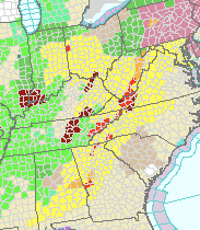
Above map is the tornado warnings in effect at 11:56pm Eastern (red). Maroon = flash flood warnings. Amber = severe thunderstorm warnings. Green = various flood warnings.
The immediate tornado threat for Atlanta (i.e., until 1am Eastern) has lessened as those cells have weakened. However, there is a chance the thunderstorms in east central Alabama could strengthen and move into Atlanta later in the night.
This is my last live-blog report of the night. Hope they have been helpful. Go to accuweather.com for continuing coverage throughout the night.


Comments
Post a Comment