
Strong Tornado Signature Moving Toward Des Moines
UPDATE: Wednesday evening: It was an F2 tornado. NWS damage survey details here.
ORIGINAL POSTING:
Tornado warning now in effect for Des Moines.
The reflectivity display (the type you usually see on television) shows a swirling echo (circle) that has produced tornadoes (arrow). The purple polygon is the tornado warning. Red is for large hail.
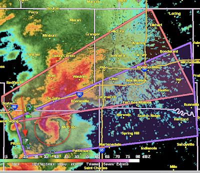
The Doppler wind data shows a VERY strong couplet (rotating winds). Please take cover if you are in the path of this storm!

UPDATE: Tornado reported by off-duty NWS employee at the location marked by circles at 6:28pm.
Below is the Doppler wind data at 6:28pm, the same time the NWS employee reported debris across U.S. 169 north of Winterset.

The "couplet" (circled) is very strong. The deep blue colors is wind flowing toward the radar and the dark red is wind flowing away from the radar. When they touch, as they do here, it is not only an indication of a tornado, it is also an indication the tornado may be "significant" (defined as F2 or stronger by meteorologists).


Comments
Post a Comment