Another Downburst
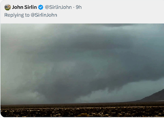
This photo, taken from the roof of WeatherData's offices in downtown Wichita late this afternoon, was in the process of producing a downburst, a burst of wind that travels down to the ground and then spreads out rapidly.
The storm is to the southeast of Wichita (very top of image) as viewed by the Wichita Terminal Doppler Weather Radar (TDWR), a radar designed to locate downbursts and microbursts (the smaller version of a downburst, 2.5 miles in diameter or smaller).
The above image is the "reflectivity" data, the same data as usually seen on television weathercasts. The storm, with the about-to-be downburst just northwest of Winfield, extends 47,000 ft. up into the atmosphere.
This image, the wind velocity display from TDWR, shows the start of the downburst with the green colors (winds toward the radar) northwest of Winfield and yellows (winds away from the radar) just north of Winfield. The darker yellows and browns south of radar (between Belle Plaine and Conway Springs) are north winds behind a cold front.
This last image shows winds of about 37 knots (43 mph) northeast of Winfield with slightly lesser winds over the Winfield Airport south of town along Highway 77. So, does the radar work? Here is the actual wind observation measured by the FAA's weather equipment at Strother Field south of Winfield:
They had a wind shift with the wind blowing from north to south at 23 knots gusting to 35 knots (40 mph). The visibility dropped to 4 statue miles with a thunderstorm with heavy rain (+TSRA).
By using this technology, a pilot would know ten minutes in advance of the potential hazard! This allows them to time a landing or takeoff for when it is safe or to divert to another airport.
Just another example of weather science and technology making life safer.


Comments
Post a Comment